About
Ownership
Links
City of Redwing
Explore Minnesota
Friends of the Bluffs
Overview
One of the most prominent natural features along the upper Mississippi River at Red Wing, Minnesota is Barn Bluff. Rising to about 400 feet, it offers breathtaking views of the river valley, the surrounding bluffs, and the city below. The bluff was created when the ancient glacial melt waters carved the Mississippi River Valley, eroding the land around it and leaving the harder Dolomite rock at the top intact.
Early Native Americans lived and traded in the area and built burial mounds on the top of the bluff. In the 1600’s, French explorers came through the area and named the hill “Mont La Grange” because it looks like a large barn; the name was eventually translated to Barn Bluff in English. Later, the area that encompasses the bluff was named Khemnichan (Hill, Water, Wood) by the Bdewakantunwan Dakota, who settled near the bluff around 1815. They also used the bluff as a lookout for approaching enemies and as a safe place for the women and children during periods of war. As a result of the Treaty of 1851, the Dakota people were removed to a reservation in the Minnesota River Valley.
Europeans eventually settled in the area, and many disembarked off steamboats at the base of Barn Bluff as they sought new lives on the frontier. As the town of Red Wing grew, the people developed quarries on Barn Bluff to obtain limestone for buildings, rip rap for railroads, and the production of lime. Residents later protested this defacing of the bluff, and quarrying was stopped. The abandoned G.A. Carlson Lime Kiln stands at the northeast end of the bluff, serving as a reminder of Red Wing’s limestone history.
In more recent years, the City of Red Wing has learned to understand how sacred the bluff is to the Bdewakantunwan Dakota people of the Prairie Island Indian Community, and the City is working together with different groups “to create a place where all people can honor, respect, and enjoy the space.”
Barn Bluff offers different activities. Hikers can get to the top by means of an easy trail, and a more difficult trail along the riverside of the bluff has a cable handrail available. Along the top, there are scenic overlooks to stop at and take photos, and interpretive signs explain about the geology and ecology of the bluff. About halfway up, there are places for rock-climbing.
A number of websites provide more in-depth information about Barn Bluff:
https://www.redwingmn.gov/343/He-Mni-Can-Barn-Bluff
https://redwingbluffs.org/he-mni-can-barn-bluff
https://www.exploreminnesota.com/profile/he-mni-can-barn-bluff-regional-park/27466
https://en.wikipedia.org/wiki/Barn_Bluff_(Red_Wing,_Minnesota)
— Kirk Nelson
History
Management
Comments


Goodhue County

Southeast Region
Location
Size
48 acres
Driving Directions
Parking
820 E 5th St
Red Wing, MN 55066
N44 34.089, W92 31.112
Hours
Fees
No fee
Maps
He Mni Can-Barn Bluff Map (PDF)
Ecology
Ecological Classification |
|
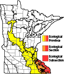 |
| Ecological Province |
 |
|
Eastern Broadleaf Forest Province |
|
| Ecological Section |
 |
|
Paleozoic Plateau |
|
| Ecological Subsection |
 |
|
The Blufflands |
|
| Land Type Association |
|
|
Elba Slopes |
|
| |
|
|
|
|
Native Plant Communities*
Sugar Maple - Basswood - (Bitternut Hickory) Forest
Dry Bedrock Bluff Prairie (Southern)
* Source: The Minnesota Biological Survey, Minnesota Department of Natural Resources, Division of Ecological Resources
Natural Features