Bluestem Prairie Additions
About • Location • Activities • Ecology
About |
||
Ownership |
||
|
||
Links |
||
Overview |
||
|
||
History |
||
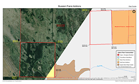
These two tracts were acquired through funding provided by the state of Minnesota’s Outdoor Heritage Fund. The fund was created on November 4, 2008, as part of the Clean Water, Land and Legacy Amendment to the Minnesota constitution, and is funded by the state sales tax. The east tract was acquired on 9/1/2011, the west tract on 5/4/2012. Both tracts are adjacent to the Northeast Unit of Bluestem Prairie Preserve. The east tract connects Bluestem Prairie to Margherita Preserve-Audubon Prairie. |
||
Management |
||
|
||
Comments |
||
|
||
Driving Directions |
 |
|||||
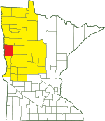
| Clay County | ||||||
| Northwest Minnesota | ||||||
Activities |
||
Hiking Trails |
||
No maintained trails |
||
Hunting |
||
All hunting. |
||
Ecology |
|||||||
Ecological Classification |
 |
||||||
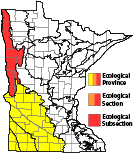
| Ecological Province | Prairie Parkland Province |
||||||
| Ecological Section | Red River Valley |
||||||
| Ecological Subsection | Red River Prairie |
||||||
| Land Type Association | Barnesville Beach Complex |
||||||
Native Plant Communities* |
|||||||
Agassiz Beach Ridge Complex Mesic Prairie (Northern) Prairie Mixed Cattail Marsh |
|||||||
| * Source: The Minnesota Biological Survey, Minnesota Department of Natural Resources, Division of Ecological Resources | |||||||
Natural Features |
|||||||
|
|||||||
These tracts protect habitat that may be used by Greater Prairie-chicken, a Minnesota special concern species, and may host western prairie fringed orchid, a Minnesota threatened species.
Visitor Photos |
|||||
Share your photo of this destination. |
|||||
| This button not working for you? Simply email us at info@MinnesotaSeasons.com. Attach one or more photos and, if you like, a caption. |
|||||
|
|||||
MinnesotaSeasons.com Photos |
|||||
|
|||||

Slideshows |
||
Visitor Videos |
|||
Share your video of this destination. |
|||
| This button not working for you? Simply email us at info@MinnesotaSeasons.com. Attach a video, a YouTube link, or a cloud storage link. |
|||
Other Videos |
|||

Visitor Sightings |
||||||||||||||||||||||||||||||||
Share your sightings or comments about of this destination. |
||||||||||||||||||||||||||||||||
| This button not working for you? Simply email us at info@MinnesotaSeasons.com. |
||||||||||||||||||||||||||||||||
MinnesotaSeasons.com Sightings |
||||||||||||||||||||||||||||||||
|
||||||||||||||||||||||||||||||||
Last Updated:

